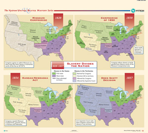
SLAVERY DIVIDES THE NATION, 1820–1857
Map on spring roller with backboard
Connect with a representative to create a custom curriculum for your district.
Divided into four equal parts, each of which shows the United States at the time of a milestone in the history of sectionalism: the Missouri Compromise (1820), the Compromise of 1850, the Kansas-Nebraska Act (1854), and the Dred Scott decision (1857). Each map indicates free states, slave states, and the date when each state was admitted to the Union, while color shading for the territories shows whether slavery there was banned by Congress, allowed by Congress, allowed by the Supreme Court, or left up to the people of the territory.
This title is part of the series: THE NYSTROM COMPLETE U.S. HISTORY MAP SET

