POLITICAL RELIEF WORLD AND U.S. MAP SET
Secondary grades
COMPLETE SET: 2 maps on 1 roller with backboard
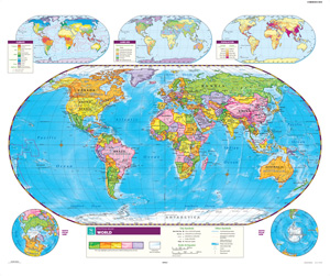
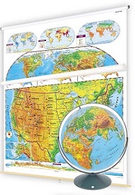
Contrasting colors in this World and U.S. map set make countries and U.S. states immediately visible, and both maps show latitude and longitude as well as capital and major cities (with type size denoting population). Both maps also offer insets showing population, climate, and land use, and the U.S. map includes insets of Alaska and Hawaii, a locator map, major highways, and a cross-continental cross-section elevation profile. Both maps measure 53"h x 65"w and are mounted together on one heavy-duty metal spring roller with a backboard.
Students who learn by doing are the most likely to retain their new-found knowledge. Bring the educational benefits of play into the classroom with Nystrom’s hands-on markable wall maps. Wall maps have been an important part of social studies classrooms for over a hundred years. As maps become more and more digital, make sure students have the learning power of a physical wall map at the ready in their classrooms.
See also:
Bring Nystrom Maps like this World and U.S. Map Set to all the students in your district! Learn more here.
| Size | 53"h x 65"w |
|---|---|
| Publisher | Nystrom |
| ISBN | 9780782510324 |